The Cordillera Real Traverse in 2024
- Jeff Cabarrus
- Aug 3, 2025
- 10 min read
Updated: Aug 3, 2025
Introduction
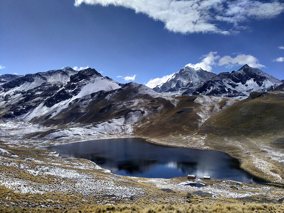
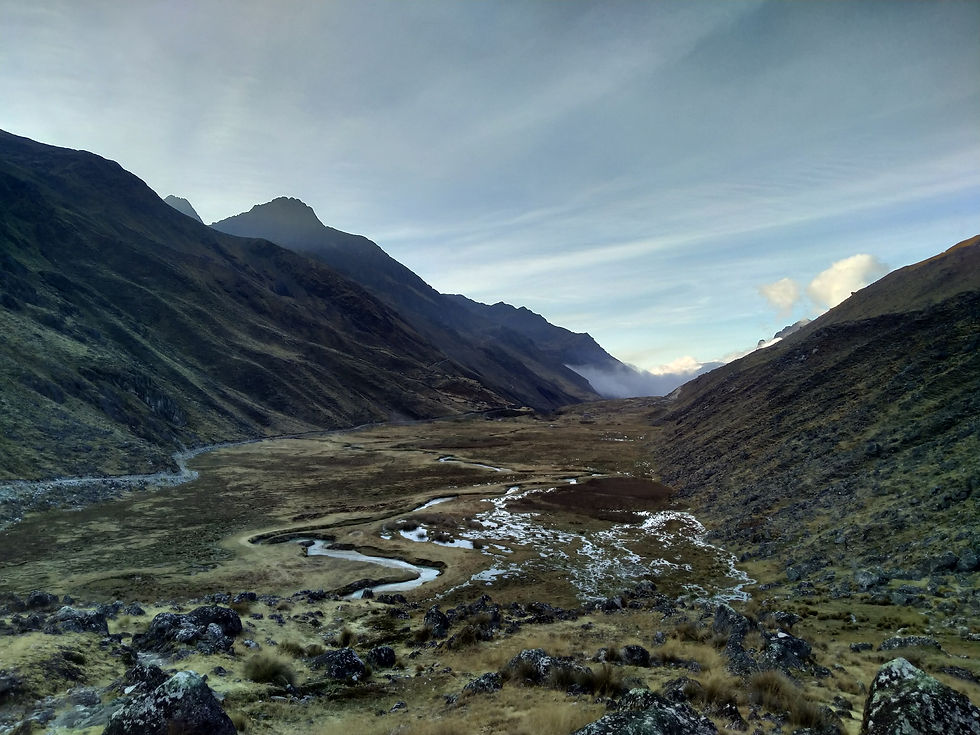
The Cordillera Real Traverse (CRT) is an absolutely phenomenal long-distance trek along the length of the Cordillera Real, with stunning views of some of Bolivia's finest snow-capped mountains and glacier-fed rivers and lakes. It's an experience I can wholeheartedly recommend to any experienced hiker with the time and resolve to do it.
This post is intended to:
consolidate useful information about the CRT from the extremely helpful pages published by The Hiking Life (Cam "Swami" Honan), Ramblin' Boy and the contributors to their blogs (Other Blogs);
where possible, fill in some of the gaps that I felt were left by the Other Blogs; and
provide up-to-date information about the CRT in 2024.
This post does not include information about general preparation for the CRT (eg food, water, equipment, navigation, acclimatisation). There are detailed suggestions on these points in the Other Blogs but, if you need general information about these points, the CRT probably isn't for you. The CRT should only be attempted independently by experienced hikers - otherwise, consider engaging a guide.
Key points
The CRT is an idea (ie to hike the entire length of the Cordillera Real) rather than a fixed route. You can make decisions along the way that will cause your version of the CRT to be easier or harder, but change what you see along the way. I've identified some key decisions below.
The hardest part of the CRT is navigation. You will not be able to rely on defined trails (even vaguely defined trails) for significant sections of the CRT and/or will regularly be forced to choose between competing llama trails. Even more than for other hikes, it's important to have your usual navigational tools to hand. Brief further comments below.
If we're being honest, I thought the most impressive part of the CRT started near Huayna Potosi and ended around where I joined the Illampu circuit (reasons explained below). Maybe unsurprisingly, this is close to the guided route taken by Ramblin' Boy in 2014 and the others in relation to whom he has since updated the page (Camilla in 2018 and Mattias in 2024). If you don't have time to complete the full CRT, I'd recommend trying a similar route.
Transport and resupply options are more or less as described by Swami, but to save you some time, I've provided some further and up-to-date details below for the parts with which I'm familiar.

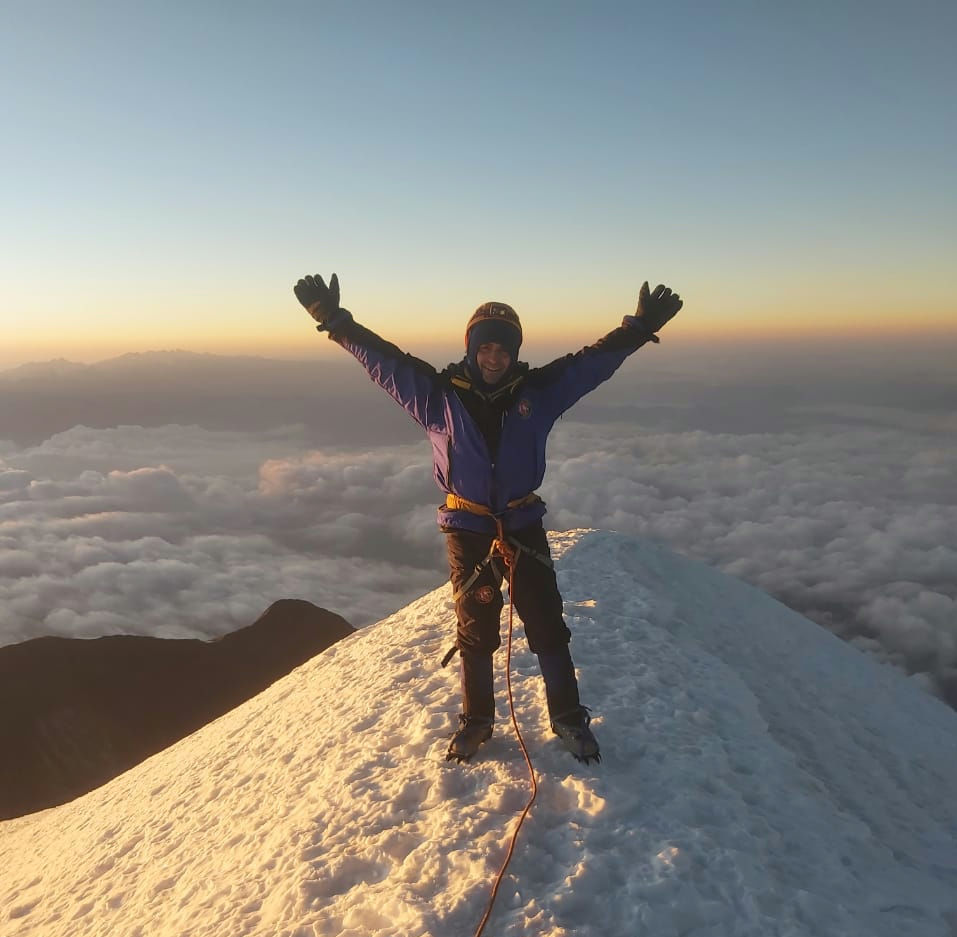
My CRT Route
I completed the CRT solo in August 2024 in around 17 days (FN1), travelling south to north. My CRT was divided into two parts, with a rest and restock day in between in La Paz. The first part was around 7 days from Cohoni to La Cumbre (FN1), and the second part was 10 days from La Cumbre to Sorata. The second part included a small restock in Cooco on day 9.
So that you have adequate context for my comments below, I've included:
my exported bookmarks from Organic Maps (FN2); and
a brief description of each day, to supplement the maps.
Exported bookmarks: GPX file
Exported bookmarks: KML file
Day-by day descriptions
Cohoni to Campamento Puente Roto (FN1).
Campamento Puente Roto to shortly before Totora Pampa (FN1).
Totora Pampa to a valley south-west of Cerro Arkhata.
Near Cerro Arkhata to Choquecota (FN1).
Choquecota to a valley south-east of Cerro Japo Japani.
Near Cerro Japo Japani to Laguna Ajuankhota.
Laguna Ajuankhota to La Cumbre.
La Cumbre to Laguna Canada.
Laguna Canada to shortly before Laguna Sura Khota and Laguna Wich'u Khota.
Laguna Sura Khota and Laguna Wich'u Khota to shortly before Laguna Juri Khota.
Laguna Juri Khota to a small valley south-west of Apacheta.
Near Apacheta to shortly past Lago Warawarani.
Lago Warawarani to shortly pas Rio Keka Jahuira.
Rio Keka Jahuira to Laguna Jistaña Khota.
Laguna Jistaña Khota to near Chajolpaya.
Chajolpaya to shortly before Ancoma.
Ancoma to Sorata.
FN1: I say "around 17 days" because I suffered food poisoning during the first part of the CRT, and 6-7 days is actually my best estimate of how long this part would have taken me if I weren't poisoned. As it happened, I moved slowly, took a full rest day at Campamento Puente Roto, and ultimately needed to divide this part into two sub-parts from Cohoni to Choquecota and Choquecota to La Cumbra. Who knew beans, if not prepared properly, could poison you? To keep the information on this page simple, I've otherwise omitted to refer to this complication.
FN2: The bookmarks of the CRT are sparse because I only intended them to be a personal record of my route, rather than a navigational tool for others. For example, I didn't create bookmarks where I was following a trail already recorded in OpenStreetMaps (because to me the route I took is implied). The bookmarks are all based on real location data, but I suspect you'll be better served using the bookmarks and trails available on Ramblin' Boys' website, at least for the northern part of the CRT.
I'm also too lazy to recategorise my bookmarks of the CRT in order to separate them from bookmarks of the other hikes I did this trip, so you'll have the pleasure of seeing what else I've done.
Key decisions
Navigational choices - Some key navigational choices are:
Tres Rios or Totora Pampa?: After the pass at P'iq'iñ Q'ara, I chose the shorter path with fewer roads travelling towards Totora Pampa. With the benefit of hindsight, even though I think there are more roads involved, it may be more interesting to go via Tres Rios, because the path after Tres Rios takes you closer to Mururata and the nearby lakes.
Circumnavigate Huayna Potosi to the north or south?: As best I could tell from Swami's trip report, he and Dirtmonger followed the road from near Laguna Zongo down towards Botijlaca and, from there, climbed back up to Paso Condoriri. To me, this seemed to go unnecessarily far down and away from Huayna Potosi, so I instead travelled via a path which takes you close to Maria Lloco and close-ish to Laguna Tuni before eventually also reaching Paso Condoriri. Without knowing both paths, I thought the path I took was an especially beautiful part of the CRT.
Circumnavigate Illampu to the east or west?: If travelling south-north, once you reach Laguna Chojna Khota, you join the Illampu circuit with the choice to travel east or west. I took the slightly longer east route, which is pleasant, if not as spectacular as other parts of the CRT (although I particularly liked the section between Abra de la Calzada and Chajolpaya) and eventually takes you to Sorata. The alternative is to travel west which, I understand, after some roads and small towns, eventually reaches the main road between Sorata and Achacachi, from which you could intercept transport in either direction. I don't know if the scenery might be better along the west route (noting that Ramblin' Boy and other tours, heading north-south, use this route).
High road or low road?: In several cases, you have the choice to either go over a pass, or travel down and up valleys that take you away from and then bring you back towards the mountains. The easiest way to see several of these options is to compare Ramblin' Boys' route (more passes) with Camilla's route (more valleys). I chose the passes on every occasion except one. Without knowing the alternative, the one time I chose the valleys, the route still presented a beautiful landscape and views.
Your Midpoint / Resupply Access Point - I chose La Cumbre because it is geographically close to the middle of the CRT, required no real detour from my route, is easily accessible from La Paz, and is on the busiest road along the CRT. It is the main road travelling to Coroico, but also the starting point for the dozens of Death Road cycling tours leaving each day, so there's no lack or potential transport to or from La Paz. However, you'll want to consider whether there might be a better option for your route.
North-South or South-North - My impressions of the key pros and cons of each direction were:
Overall altitude gain and loss: At ~2600m, Sorata is by far the lowest point of the CRT. This means that, if you choose to start from Sorata, you'll be faced with a relatively dull and lengthy start to the CRT before reaching higher altitudes. This could of course be avoided by choosing a different northern terminus, such as the point on the main road shared by Ramblin' Boy and Camilla's route.
Route difficulty: My impression was that the routes taken by Ramblin' Boy and Camilla could be covered more easily travelling north-south, given the different types of terrain on each side of the passes. But this might just reflect my personal terrain preferences (or maybe the grass always looks greener on the other side).
Resupply: One clear advantage of travelling south-north is access to Cooco for a resupply late in the trek. There is no equivalent before La Cumbre (or whichever place you choose as your midpoint) if you're travelling north-south.
Transport and accommodation options: If ending in the north, Sorata has plenty of accommodation options and transport to La Paz is exceptionally convenient. I'm less sure about the situation if you instead finish on the main road between Sorata and Achacachi, but my full minibus from Sorata drove past plenty of locals who were looking for passage to La Paz along that road. On the other hand, if you end in Cohoni, there will be fewer and less frequent minibuses to La Paz, and I didn't notice any clear accommodation options.

Navigation
I found the bookmarks and trails available for download from Ramblin' Boys' blog extremely useful for planning my CRT route and for actually navigating the corresponding part of the CRT. I imported them directly into Organic Maps.
If you want to buy a physical map (recommended - and personally I like having the souvenir), I bought mine from Sampaya on Calle Illampu in La Paz (~30 BS). However, I also saw them for sale in the neighbouring store and at The Wall on Avenida 6 de Agosto.
Alternatives to the CRT
The nature of the CRT is decisions and alternatives. However, as I mentioned, if you don't have time for the entire CRT, a particularly promising and shorter alternative would be a route that more or less replicates those taken by Ramblin' Boy, Camilla or Mattias. You'll still face a substantial challenge and plenty of decisions and alternatives.
I found the part of the CRT that they explored to be the most impressive. To give you some insight as to why, I'm inclined to point to the weaknesses of other parts of the trek, namely:
south of La Cumbre - there are fewer snow-capped peaks than north of La Cumbre (which for me are key highlights). Certain parts of the route are also heavily affected by mining or other commercial operations. In particular, the valleys surrounding P'iq'iñ Q'ara are dominated by mining operations. After a chat, the miners didn't seem to have any issues with me passing through, but the mines are a blight on the landscape; and
in the north, after I joined the Illampu circuit - the area is significantly more developed with roads and towns, including some mining operations (although much less than near P'iq'iñ Q'ara). Depending on what you like, this might not be a problem, but I prefer to avoid anything that isn't nature at its purest! Otherwise, this part felt to me more like a 'standard' hike, with significant time travelling along the bottom of valleys, without the absurd views that featured on other parts of the CRT. You could potentially get a similar experience elsewhere, which I think is much harder to say for the central part of the CRT.

Transport
La Paz to Cohoni - Minibuses and buses to Cohoni depart from Calle Luis Lara, near the corner with Calle Riobamba (more or less accurately marked on OpenStreetMaps).
I arrived shortly before 8am and was told by a shop owner that there was no minibus until one scheduled for 10am, for which she sold me a ticket. As it happened, not only was there another minibus which left before 10am, the scheduled "10am" minibus didn't leave until around 12pm when all the seats were finally sold (no surprises there).
There was also a bus to Cohoni that departed before my minibus. However, my minibus ultimately overtook the bus, which broke down on the steep roads to Cohoni. The best bet would seem to be sticking to the minibuses.
Price: ~20 BS
La Paz to La Cumbre - Minibuses to Coroico depart from Terminal Minasa, and La Cumbre is along the way. There seemed to be plenty of operators running this route. You'll need to ask the driver to drop you at La Cumbre.
Price: ~30 BS
Sorata to La Paz - Minibuses to La Paz depart from a parada on Camino Achacachi-Sorata (as marked on OpenStreetMaps). I took what I think was the first minibus at around 8am, but there were several minibuses queued and plenty of demand.
The final stop for the minibus was at the Terminal de Transporte Interprovincial in El Alto, which is reasonably close to a teleferico station.
Price: ~20 BS

Resupply
The resupply options are essentially as described by Swami (ie Palca; La Paz/Coroico via La Cumbre; La Paz via Huayna Potosi refugios; Cocoyo). I would only add that:
as for a restock in Palca, if you only need a basic restock, it may be a significantly smaller detour to restock in Choquecota or Ventilla. Each of these has some very small shops; and
returning from La Paz from the Huayna Potosi refugios might be more feasible than Swami thought. There are now several Huayna Potosi tours running each day during high season (unfortunately for the mountain), so it may not be too difficult to negotiate a ride to La Paz with one of the transports.
Miscellaneous
Cooco - It stood out to me that, under the subheading 'Dangers', Swami says "Cocoyo [Cooco, Cooca] wasn't the most welcoming place I've visited in Bolivia. Indeed, it was the only time on the journey that we even gave a second thought to security issues".
It would be remiss of me to leave out that I had a very different experience of Cooco. The locals were extremely generous in helping me to find an open store so that I could restock and were happy to chat about my CRT adventure.
The Hiking Life - Full credit to Swami for developing the idea of the CRT and being part of the inspiration for me to undertake it. The Hiking Life is am amazing resource and I strongly recommend you take a look at what it has to offer!


Comments